


Speedo MapTrack - GPS Speedometer with Maps
Descrizione di Speedo MapTrack - GPS Speedometer with Maps
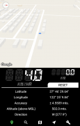
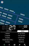
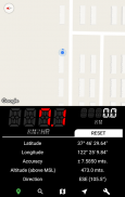
Speedometer and Maps stitched together!
Speedo MapTrack is ideal for people who want their location details (speed, distance etc.) along with their position & direction on Google Maps.
Can be used while travelling in train, bus, car etc.
Features:
Split view of map and the speedometer console.
--- Map ---
• Supported up to 6 different themes.
• All the gestures & moves from google maps works.
• Map pointer moves along with the user's location.
• Shows live traffic on roads.
• Location search feature included.
• Also has a satellite view.
• Various power modes (affects accuracy).
--- Speedometer ---
• Speed - (km/hr, mi/hr, mtr/sec)
• Distance Travelled - (km, miles, meters)
• Latitude - (Decimals, DMS)
• Longitude - (Decimals, DMS)
• Altitude.
• Direction of travel.
• Accuracy of the location obtained.
• Speed limit alert/warning.
• Display precision can be set (decimal points).
• Supports 2 themes (Dark & Light).
Tachimetro e Mappe cuciti insieme!
Speedo MapTrack è ideale per le persone che vogliono i loro dettagli della posizione (velocità, distanza, ecc) insieme con la loro posizione e la direzione su Google Maps.
Può essere utilizzato durante un viaggio in treno, autobus, auto, ecc
Caratteristiche:
Split vista della mappa e la consolle tachimetro.
--- Carta geografica ---
• supportati fino a 6 diversi temi.
• Tutti i gesti e si sposta da Maps Google opere.
• Mappa puntatore si sposta insieme alla posizione dell'utente.
• Mostra traffico in tempo reale sulle strade.
• Posizione funzionalità di ricerca incluse.
• Inoltre dispone di una vista satellitare.
• Varie modalità di alimentazione (influisce precisione).
--- --- Tachimetro
• Velocità - (km / h, mi / hr, mtr / sec)
• Distanza percorsa - (km, miglia, metri)
• Latitudine - (decimali, DMS)
• Longitudine - (decimali, DMS)
• altitudine.
• Senso di marcia.
• Precisione della posizione ottenuta.
• Avviso limite di velocità / avvertimento.
• Precisione di visualizzazione può essere impostato (punti decimali).
• Supporta 2 temi (chiari e scuri).
Speedo MapTrack - GPS Speedometer with Maps - Versione 1.2.1b
(02-06-2018)Speedo MapTrack - GPS Speedometer with Maps - Informazioni APK
Versione APK: 1.2.1bPacchetto: com.akashunni.speedometerUltima versione di Speedo MapTrack - GPS Speedometer with Maps


 3.55
3.55


App nella stessa categoria


